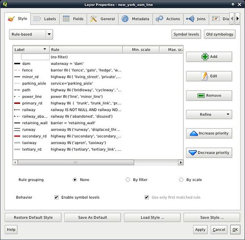
The first thing that nearly everyone wants to see on a map are the linear features: streets, roads, railroads, canals, tracks and so on. We've already loaded a wealth of information about these from Open Street Map into the PostGIS database. But we still need to show the stuff with appropriate styling. This styling winds up getting done with progressively more complex sets of rules, distinguishing one type of line from another: people like to see, for instance, a specific style of line for “hard surfaced secondary road” or “abandoned railroad.” Coming up with these rules is rather tedious, and I won't make you read through an entire posting of what the rules are. Rather, I'll just refer to QML files that contain the rules and link to them at the bottom of the posting.
The first thing we're going to have to do with the lines in the Open Street Map data is to get rid of the ones we don't want. Administrative boundaries, we'll skip for now. (I'm still working on getting those styled well.) We've already mostly done the waterways: we want to do some additional work to put in dams, locks, rapids and so on, but we want to exclude the lakes and streams. And 'routes' - such as numbered highways - duplicate the roads. We'll handle them separately.
So we need to select ‘new_york_osm_line’ (or whatever name we used to import the line graphics), and pull ‘Query’ from the 'Layer' menu. We enter the SQL query:
upper(geometrytype("way")) IN ('LINESTRING','MULTILINESTRING')
AND ("waterway" IS NULL
     OR "waterway" IN ('breakwater', 'dam', 'dock', 'flume', 'lock_gate',
                       'rapids', 'waterfall', 'weir'))
AND ("boundary" IS NULL)
AND ("route" IS NULL)
(Read the query as: “We want only line graphics, that aren't waterways, boundaries, or routes, except that breakwaters, dams, ..., weirs are acceptable waterways.) Now we have a manageable set of lines to work with. After considerable fiddling, we come out with a set of rule-based styles to render them:
We also want to show highway numbers. While showing them on shields is promised functionality for QGIS, it isn't in the development main line yet. So for right now, we just use ordinary labels. We create a new layer against the same OpenStreenMap line layer, changing the query this time to:
"highway" IS NOT NULL AND "ref" IS NOT NULL
(which selects numbered highways). We render nothing for this layer: the easiest way to do this is to select “Simple Line” as the rendering style, and then select “No Pen” as the pen style. We use the “Labeling” dialog (from the “Layer” menu) to put in the labels, giving them a red foreground and a white buffer. When QGIS gets highway shields, we'll be able to change this one place and show proper shields instead.
Not too bad! The QML for the street style sheet is attached at the end of the post.
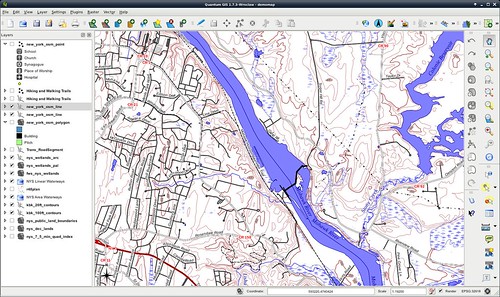
Next time, we'll start putting in some land use data, and add some building footprints.
Attachments
- OSM-highway-style0.qml - Initial attempt at OSM highway styling.
No comments:
Post a Comment