What with one thing and another, Kevin didn't manage the "zero-dark-thirty" start time he'd hoped for. He also had some uncertainty about campsites, because a friend had warned him that the sites he'd planned in the event of a late start were closed. So when traffic on the way down to the southern Catskills proved slow-moving (there was some sort of foot race taking place on Route 30), he decided to adjust starting point and began at the Giant Ledge trailhead on County Road 47, rather than at the Woodland Valley campground. He didn't actually get on the trail until nearly noon.
The trailhead sports a lovely new bridge, replaced in the repairs after Hurricane Irene. The nearly-washed-out signpost was not replaced in the same repairs, and leans at a crazy angle.

All the blowdown in the storm has been a bonanza for the decomposers. Kevin spotted an enormous colony of puffballs growing on one downed tree.

The autumn leaves were in full colour as Kevin started up the moderately steep trail. This year's display is, alas, something of a disappointment. A dry August has meant that the leaves started to brown off before they fully turned colour. Nevertheless, what colour there is, is lovely.

For whatever reason, Kevin wasn't in top hiking form. He was aware of this, and decided to forgo the views on Giant Ledge - which, after all, he's seen before and intends to see again - and just press on. It took him several hours to make it to the campground in Woodland Valley, first up onto the ridge, then down into a ravine, and then up again on a long series of rock steps that the hikers sometimes call the Stairway to Heaven.
Kevin was treated to a typical bear sighting on the way: the hind end of a bear sow, disappearing at the gallop into the brush. No time to grab a camera before she was gone. (It's just as well. Seeing more of a bear is likely to be a problem.)
Down at the campground, Kevin astonished some of the tourists. "Do you know where Campsite #50 is?" "No, sorry, I'm just hiking through." "You're not staying here?" "No, I'm tenting up in the woods somewhere." "You spend the night in the woods?" "Well, yeah."
In any case, the campground provided Kevin an opportunity - which every backpacker knows is not to be missed - to use the porcelain privy. His load considerably lightened, he began the ascent of the Burroughs Range Trail.
Still moving slowly, in the late afternoon, he came to the last spring before the trail junction to Terrace Mountain. This is the last reliable water before crossing the Wittenberg and Cornell Mountain. He rapidly consumed his last litre of water, so as to have as much room as possible to take on fresh water, and refilled water bottle and bag, treating the water because the spring is running a mere trickle, looks dodgy, and tastes tannic.
Just about this time, Kevin's phone bleated about a low battery? (What? It's been in airplane mode all day, and the screen has been lit only a few times. True, the GPS has been running, but it'll usually last a couple of days that way!) It was noticeably warm to the touch. Kevin speculated that some application has gone into an infinite loop and shut the phone down. (Note to self: Reboot the phone at the trailhead!) The GPS track beyond the spring is lost. Kevin then continued up the trail, and discovered he was hiking much faster - perhaps he was running a bit dehydrated, despite remembering all day to drink?
In any case, it was too late in the day to contemplate climbing the Wittenberg, and Kevin turned left for the Terrace Mountain shelter. He crossed the overlook uneventfully, and got within a few hundred yards of the lean-to, but heard the noise of quite a large group of hikers there. Recognizing that there would be no space in the lean-to, and having seen an attractive stand of hemlocks a short distance back, he made an abrupt U turn, headed back into the hemlocks, swung off trail a couple of hundred feet on what appeared to be a faint herd path, and arrived at a rock outcropping covered with dead moss. The outcropping has a convenient rock to serve as a kitchen table.

There's a nice flat spot under hemlocks not to far away to serve as the bedroom in Kevin's home-away-from-home.

And a well-positioned tree branch served for the pantry. Kevin managed to get his line over it on only the second cast.

He started his dinner - Italian trail glop (couscous, cubes of abruzzese sausage, shredded string cheese, and a tomato sauce compounded from dehydrated vegetables, tomato powder, herbs and spices) steeping in the freezer bag cozy. Oh good Heavens, he's forgotten to pack the olive oil! Just as well: the sausage is entirely greasy enough!
While dinner was steeping, Kevin pitched his tent, inflated his crash pad, unrolled his sleeping bag, arranged the rest of his duffel, and it was time to eat. The Italian glop (based on a recipe at trailcooking.com, but considerably modified) was pronounced a winner - suitable for being in the rotation on subsequent trips. It's tasty.
After washing up the kitchen, evening ablutions, and the hanging of the bearbag, it was time to crawl into the sleeping bag, review the map for the morrow, and plug the phone into the Minty Boost. Oh, [Nixonian expletive deleted]! The Minty Boost batteries are dead, too! (Note to self: Do not store the Minty Boost with batteries in place!). Kevin has packed a couple of pairs of spare lithium batteries in the camera case, and a battery swap soon had the phone charging. (It can get about a 50% charge off one pair of lithium AA's.) Kevin felt an overwhelming urge to close his eyes, and has soon drifted off peacefully as the fall of hemlock needles made a quiet patter on the tent.
About five in the morning, Kevin needed to make a brief predawn trip outside the tent. Returning to the sleeping bag for a moment to take the chill off, he decided to pack up by headlamp and get an early start on hiking. He pulled the sleeping bag around his head to warm his ears, rolled over, and found the sun shining brightly and his watch saying that it was a quarter to eight. He's slept nearly twelve hours! (Must have needed it: it had indeed been a stressful week.)
Kevin retrieved the bear bag, made coffee, packed up, and headed off in jig time - rolling in less than a half hour and eating breakfast on the move.
The Terrace Mountain overlook is a trifle overgrown, but with the leaves mostly off the trees, it offers some nice views. Kevin realized that the weather today might be iffy, with the peaks shrouded by a thin cloud layer.

An obstructed glance at the Wittenberg showed him how far he had yet to climb.

Beyond the trail junction, the ascent of the Wittenberg grows somewhat arduous, with many rock scrambles to negotiate. Nevertheless, Kevin made decent time, and by midmorning, he was taking in a spectacular view from the summit, above all the thin clouds he noticed on the way up. As Burroughs wrote,
The solitude of mountain-tops is peculiarly impressive, and it is certainly easier to believe the Deity appeared in a burning bush there than in the valley below. When the clouds of heaven, too, come down and envelop the top of the mountain,—how such a circumstance must have impressed the old God-fearing Hebrews! Moses knew well how to surround the law with the pomp and circumstance that would inspire the deepest awe and reverence.

Click through to get larger views!
Kevin met only a handful of other hikers on this peak, and after only a few moments of photography and socializing, set off on the Bruin's Causeway for Cornell Mountain. This ridge is an interesting formation. It is nowhere more than about fifty feet wide, with sheer cliffs dropping from both sides. It is a highway for wildlife, including the eponymous bears, who have left unmistakable evidence of their presence.

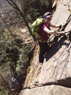
The west face of Wittenberg has presented more rock scrambling, but nothing nearly as challenging as the east face of Cornell, infamous for the Cornell Crack, a precipitous climb up a narrow chimney. Kevin once again found himself too preoccupied with climbing to have attention to spare for photography, but later found another climber's trip report with a spectacular photograph of the scene.

(Source: Backpacking Light)
It's late enough in the season that unexpected ice is a possibility, and so the trail maintainers have fixed a piece of static line in the crack. Kevin gratefully made use of the rope, and the combination of the rope and the grippy nature of the rock made climbing to the top almost anticlimactic.
At the top, Kevin met a friendly but terrified 110-pound (50 kg) Alsatian named Zeus, whose family faced a problem. Zeus had somehow managed to ascend Cornell Mountain (and traverse Slide), but, having seen the Crack, he was now balking at every route of descent that Cornell offers. Two family members have been attempting to find a bushwhack route around the Crack (with limited success), and were now hiking back to their base camp to at least fetch their supplies and the dog food. Zeus had no climbing harness. Alas, Kevin had no bright ideas to offer (and no idea what the counterpart of a Swiss seat might be for a dog), so regretfully wished the family luck, and continued up. The Crack is only a few feet of elevation below the summit, which lies perhaps a hundred feet (30 m) off the Burroughs Range trail on a side trail. The summit overlook is nearly completely overgrown, but offers an obstructed view of the Ashokan reservoir through the clouds below.

A rock outcropping a few steps further along offers much better views to the north and west, including the eastern half of the Devil's Path,

and Slide Mountain - Kevin's next destination - with the scar of its eponymous avalanche still making a diagonal slash downward and to the right of the summit a century and a half after the rockslide.

Coming off this outcrop, the trail drops again over steep scrambles. The abrasion of the conglomerate rock air-conditioned the seat of Kevin's pants. Kevin was saved embarrassment only by being unaware that he was now displaying his black compression shorts to everyone standing behind him. (This accident surely means that he did not present the best of impressions to the people that he was about to encounter!)
Once in the col, the trail becomes a pleasant level walk through balsam forest, with some of the mixed-deciduous woods still making an occasional incursion. Just as spring is the time for wildflowers, autumn is the time for mushrooms, and Kevin noticed some odd white-rimmed bracket fungi clinging to a tree.

The surface of the trail appears almost to be the work of man, since it is composed of white quartz pebbles that have eroded out of the "pudding stone" on the higher slopes and rolled down into the col. This section, called the Garden Path, is not quite like anything Kevin has hiked before.
The DEC has marked three camping areas in the col. Kevin's friend was wrong: camping is indeed permitted up here! Kevin notes the fact for future reference.

At the west end of the ridge, the trail again becomes steep, with a difficult 700-foot ascent to the summit of Slide Mountain. Again, Kevin was too focused on climbing to pay attention to photography, but once again, someone else's trip report offers a photo that says it all:
 | |||||
| Source: Zee Lemons: "To the Crack and back" |
Shortly above this hair-raising scramble, Kevin encountered the Slide Mountain spring. This is a reliable source of sweet water at about the 3900-foot level, quite an unusual thing to find at that elevation in the Catskills. Since there had been no usable water source since the previous evening (Kevin failed to find the spring that supposedly exists along the Garden Path), Kevin was quite grateful to discover this source, finished his last cupful of water, and tanked up again.
Above the spring, Kevin encountered a gentleman and a lady hiking together, discussing the works of John Burroughs. They're hiking at about the same speed, and the three proceeded up the four long stairways and the remaining short scrambles to the mountain's summit. There the woman pointed out the errors in the Burroughs quote on the memorial tablet, and the three sat down to a late lunch. (Kevin had nibbled a few snacks on the trail, but had been sort of trying to hurry up to this point and hadn't stopped for a meal.)
The lady proceeded to pull out of her backpack an old volume of Burroughs, and commenced a reading of The Heart of the Southern Catskills. Kevin found himself drawn into a literary circle atop Slide Mountain - the subject of that essay - and learnt that the pair had been reënacting the hike that Burroughs describes in it! At the conclusion of the reading, they went on discussing the essay and their experience with the bushwhack ascent up the northern rampart of the mountain. They brought out a split of Champagne, poured out thimblesful, and invited the other hikers present to share in a toast to their patron author and their successful reënactment.
It turns out that the lady is named Joan Burroughs, and she is the great-granddaughter of the author and naturalist. Her companion is the experienced Catskill guide, Paul Misko, who is well qualified to accompany her on this adventure, having written most recently on his personal Catskill bushwhacking exploits in the Catskill Mountain Guide. Ms. Burroughs is the treasurer of the John Burroughs Association, which maintains Slabsides, the author's cabin, and its surrounding nature preserve, and sponsors annual awards for natural history writing. Kevin promised to repay her graciousness with a visit someday to Slabsides, and perhaps take out an Association membership.
By now, it had grown late enough in the day that Kevin's original plan to hike at least as far as a campsite on the East Branch of the Neversink River would mean hiking (and hanging a bearbag!) by headlamp. Since going even that far would leave him with a long hike on Monday to score additional peaks and still get back to his car, Kevin decides to hike on out to the Slide Mountain trailhead.
There are no regrets at this decision. The mountains will be there another day: they belong to the ages: their rock has rested in its place since the Devonian Sea laid it down, and their contours were excavated by the Ice Age. But the Burroughs reading was ephemeral: never again would that particular chance come along. If Kevin's purpose in hiking be to live in the moment, then a moment that presents itself must be seized!
On the way to the trailhead, Kevin shared a wistful story with the pair: he has noticed that Misko wears a patch from the 1973 Boy Scout jamboree at Valley Forge. The very first time that Kevin had ascended a 4000-foot peak, just over 40 years ago, was in the company of a man who had also attended that jamboree. Alas, their friendship was not to last long: within a couple of months after that climb, Kevin's friend lost his life in a plane crash: the plane that lies wrecked near the summit of Equinox Mountain in Vermont is his. Kevin confided that as the couple toasted Burroughs, he offered a silent toast to his late friend of four decades ago. Rest in peace, Charlie!
At the trailhead, Ms. Burroughs graciously offered Kevin a lift back to his car, sparing him a few miles of roadwalking by headlamp. Kevin gratefully accepted, and a few minutes later, bade the couple adieu, loaded his pack into his own car, and headed home.
What went right: A totally unexpected prowl through living American literature. Three successful ascents of Catskill high peaks, all involving tough Class 4 rock scrambles. Kevin's new tent used in earnest for the first time performs splendidly.
What went wrong: Too many dead batteries! Kevin must remember to reboot the smartphone before setting out (killing off background applications that might start running away), and remember not to store the Minty Boost with batteries in place, lest its USB connector encounter a short circuit.
Water was uncomfortably low by the time Kevin reached the spring on Slide Mountain: he'd have been in bad shape if it had run dry - not impossible after the late-summer drought! Carrying a fourth litre of water when approaching a high Catskill ridge from a dry camp would not be a bad idea.
Lessons learnt: The good that lies in human nature still shines brighter on the trail than in town. At each difficult scramble, successive parties overtook one another. All took turns spotting for one another, hauling one another's packs, and in general being helpful and pleasant. Not a trace of the nastiness that perennially infects our cities appeared on the mountains.
And most important: be always open to a serendipitous encounter. A plan is only a plan: sometimes a departure from the script proves to be a jewel.
Read more...


